

| |
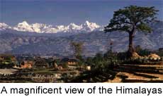 The Himalayas, the highest mountain ranges in the world, is one of the
world's youngest mountain ranges. It runs practically uninterrupted for a
distance of some 2500 km and covers an area of about 500,000 sq km. It contains
the world's highest mountain peak, Mt Everest and some ten peaks, rising above
7,500 m. It appears to have risen as a result of collision between the drifting
Indian peninsular plate and the Tibetan plate of South Asia about 50 million
years ago. The Himalayas reached their present height much later.
The Himalayas, the highest mountain ranges in the world, is one of the
world's youngest mountain ranges. It runs practically uninterrupted for a
distance of some 2500 km and covers an area of about 500,000 sq km. It contains
the world's highest mountain peak, Mt Everest and some ten peaks, rising above
7,500 m. It appears to have risen as a result of collision between the drifting
Indian peninsular plate and the Tibetan plate of South Asia about 50 million
years ago. The Himalayas reached their present height much later.
Patkai and allied mountain ranges run along the Indo-Bangladesh-Burma border and may be collectively called Purvanchal or eastern mountains. These ranges forming an arc must have come into existence along with the Himalayas. Aravalli range in north-western India is one of the oldest mountain systems in the world. The present Aravalli range is only a remnant of the gigantic system that existed in pre-historic times with several of its summits rising above the snow line and nourishing glaciers of stupendous magnitude which in turn fed many great rivers. Vindhyanchal range traverses nearly the whole width of peninsular India - a distance of about 1050 km with an average elevation of about 300 metres. The Vindhyanchal range is appears to have been formed by the wastes created by the weathering of the ancient Aravalli ranges. Satpura range, another ancient mountain system extends for a distance of 900 km with many of its peaks rising above 1000 metres. It is triangular in shape, with its apex at Ratnapuri and two sides running parallel to the Narmada and Tapti rivers. Sahyadri or Western Ghats, with an average height of 1200 metres, is about 1600 km long and runs along the western border of the Deccan plateau, from the mouth of the river Tapti to Kanyakumari. It stands overlooking the Arabian Sea. Eastern Ghats bordering the East Coast of India, is cut up by the powerful rivers into discontinuous block of mountains. In its northern parts between the Godavari and the Mahanadi rivers it rises to above 1000 metres. The Desert region can be divided into two parts - the great desert and the little desert. The great desert extends from the edge of the Rann of Kachchh beyond the Luni river northward. the whole of Rajasthan-Sind frontier runs through this. The little desert extends from the Luni between Jaisalmer and Jodhpur up to northern wastes. Continue.........
|
Copyright ©2000 indiansaga.info. All rights reserved.
By using this service, you accept that you won't copy or use the data given in this website for any commercial purpose.
The material on indiansaga.info is for informational & educational purpose only.
This site is best viewed at 800 X 600 picture resolution.