

| |
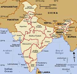
India is a large country in southern Asia. It is the second largest country in the world in population. The river valleys of northeastern India are among the most densely populated places in the world. India ranks seventh in the world in area. India occupies a strategic position in Asia, looking across the seas to Arabia and Africa on the west and Burma , Malaysia and the Indonesian archipelago on the east. Geographically, the Himalayan range keeps India apart from the rest of Asia. India has great varieties and differences in both its land and its people. The land includes desert, jungles, and one of the world's rainiest areas. India also has broad plains, mighty rivers, the tallest mountain system in the world, and tropical lowlands. The people of India belong to many different ethnic groups and religions. They speak 14 major languages and more than 1,000 minor languages and dialects.Location India lies to the north of the equator between 8 degree 4 minutes and 37 degree 6 minutes north latitude and 68 degree 7 minutes and 97 degree 25 minutes east longitude. It is bounded on the south-west by the Arabian sea and on the south-east by the Bay of Bengal. On the north, north-east and north-west lie the Himalayan ranges. Kanyakumari constitutes the southern tip of the Indian peninsula where it gets narrower and narrower, loses itself into the Indian Ocean. Extent India measures 3214 Kms from north to south and 2933 Kms from east to west with a total land area of 3,287,263 sq kms. It has aland frontier of 15,200 kms and a coast line of 7516.5 kms. Andaman and Nicobar islands in the Bay of Bengal and Lakshadweep in the Arabian sea are parts of India. Neighbours India shares its political borders with Pakistan and Afghanistan on the west and Bangladesh and Burma on the east. The northern boundary is made up of the Sinkiang province of China, Tibet, Nepal and Bhutan. India is separated from Sri Lanka by anarrow channel of sea formed by the Palk Strait and the Gulf of Mannar. Physiographic regions The mainland comprises seven regions.
Mountain ranges They are seven :
Continue........... |
Copyright ©2000 indiansaga.info. All rights reserved.
By using this service, you accept that you won't copy or use the data given in this website for any commercial purpose.
The material on indiansaga.info is for informational & educational purpose only.
This site is best viewed at 800 X 600 picture resolution.