|

|
States
Union Territories
|

|
| |
 Bihar is one of India's most densely populated state. In the north, the flat plains of the Ganges (Ganga) River are an agricultural area. The Chota Nagpur Plateau in the south has rich mineral resources. Coal and iron ore are mined in this region.
Location and description. Bihar is a landlocked state. Bihar shares an international border to the north with Nepal. To the east is West Bengal and to the south, Orissa. Bihar has a short border with Madhya Pradesh to the southwest, and its western border is with Uttar Pradesh.
From the Siwalik foothills of the Himalaya, the boundary stretches 600 kilometres south to the forested borders of the Chota Nagpur Plateau, while its maximum east-to-west width is about 480 kilometres.
Climate. The average minimum temperature on the plains of the north is 11 °C, rising to 27 °C from June to August. Average maximum temperatures range from 24 °C in January to 39 °C in May. Temperatures then fall slightly after the start of the rainy season. On the Chota Nagpur Plateau, it is several degrees cooler in both winter and summer.
Most of Bihar receives more than 1,100 millimetres of rain a year. The east receives more than the west. About 95 per cent of the rain falls between June and September. Only 8 millimetres falls in November and December, and a further 15 millimetres in March and April.
Tourist centers: Following are brief descriptions of some of Bihar's interesting places to visit-
Betla, in Palamau district, has a national park and wildlife reserve, which is famous for its tigers. Hazaribagh is also a wildlife sanctuary. Bodh Gaya is one of the most important pilgrimage centres for Buddhists. It is the place where the Buddha attained enlightenment.
Gaya is a holy place for Hindus. Pilgrims make offerings for their ancestors at the Vishnupad temple and the temple of the Sun God. Patna developed on the site of Pataliputra, the capital of the Maurya Empire. The city contains remnants from that period. Ranchi is a scenic hill resort with a number of waterfalls nearby.
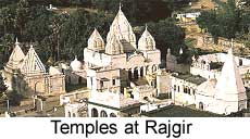
There are airports at Patna, Ranchi, Jamshedpur and Gaya. Jamshedpur and Bokaro are steel towns. Nalanda was one of the great seats of learning in ancient India and contains the ruins of many Buddhist temples and monasteries. Sasaram is famous on account of the magnificent tomb of Sher Shah Suri, Emperor of Delhi.
Land features. The Ganges River runs from west to east through the heart of the plains which comprise the state's central region. The plains are almost flat and lie about 75 metres above sea level.
The Chota Nagpur Plateau is not one plateau, but a series of plateaus and valleys. The highest, Hazaribagh Plateau, has an average height of about 1,100 metres. Its highest point is the granite peak of Parasnath (1,365 metres).
The next lower plateau, Ranchi Plateau, is composed of granite with undulating topography and averages 600 metres above sea level. The highest of the remaining plateaus has an average elevation of 300 metres. The valleys and plains of the Chota Nagpur region lie between 200 and 300 metres. The most important of the valleys is the Damodar Valley.
In the late 1960's, one-fifth of the land in Chota Nagpur was still forested. This area has since decreased dramatically. The Chota Nagpur Plateau, despite being an area of industry, is still extensively cultivated. However, some large areas of sal forest remain.
Continue with Bihar's history.....
|